Email distribution list: Click here to subscribe.
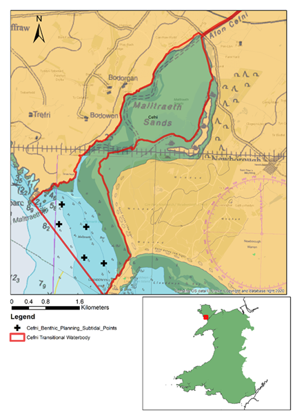
Local Notice to Mariners 2026 – Benthic Survey – Malltraeth
Benthic Survey (Malltraeth) NtoM
17/03/2026 – Bae Caernarfon – Siart 1970 – Caernarfon Bay – Chart 1970
The Environment Agency/Briggs Marine are scheduled to undertake a small scale scientific survey (sediment grab sampling) in the Malltraeth area from the vessel Severn Guardian.
Survey Details
Survey Period: 07/04/2026 – 23/04/2026
Survey duration: 1 day
Time on station: 15-60 mins
Survey Vessel: Severn Guardian
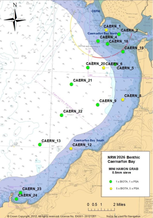
Local Notice to Mariners 2026 – Benthic Survey
Benthic Survey (Caernarfon Bay) NtoM
26/03/2026 – Bae Caernarfon – Siart 1970 – Caernarfon Bay – Chart 1970
The Environment Agency/Briggs Marine are scheduled to undertake a small scale scientific survey (sediment grab sampling) in the Caernarfon Bay area from the vessel Severn Guardian.
Survey Details
Survey Period: 07/04/2026 – 23/04/2026
Survey duration: 2 days
Time on station: 15-60 mins
Survey Vessel: Severn Guardian
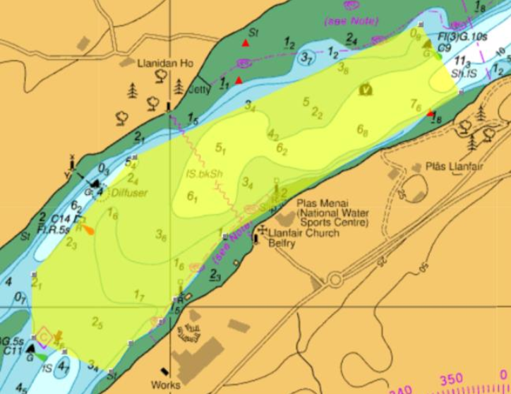
Local Notice to Mariners – 01/2026 (Cyngor Sir Ynys Môn)
01-26 NtoM (Cyhoeddwyd gan/Issued by: Harbwr Feistr Porthaethwy/Menai Bridge Harbormaster)
04/03/2026 – Y Fenai – Siart 1464 – Menai Strait – Chart 1464
Pont Menai – Menai Bridge
Gwaith Pont Menai
Hysbysir morwyr y bydd traffig masnachol cynyddol rhwng 8 Mawrth 2026 a 14 Mawrth 2026 yn gweithredu yn yr ardal a nodir ar y siart uchod, yn enwedig yn ystod ac o amgylch cyfnodau llonydd y dŵr isel.
Bydd y traffig hwn yn cynnwys pontŵn a cwch tynnu a all fod angen iddynt ddal eu safle am gyfnodau estynedig. Bydd y pontŵn a’r llongau yn arddangos y siapiau dydd neu’r goleuadau priodol.
Dylai morwyr fordwyo gyda gofal ac yn cynnal pellter diogel oddi wrth y llongau. Os oes unrhyw amheuaeth, dylai morwyr gysylltu â’r llong wrth gefn Delta2 ar Sianel VHF 16.
Dros nos, bydd llongau mawr yn angori yn agos at y marc ‘X’, gan arddangos y goleuadau angori priodol.
Mae’r hysbysiad hwn yn ganslo am 23:59 ar 14 Mawrth
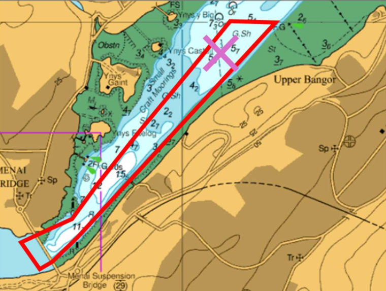
Menai suspension bridge works
Mariners are advised that between 8th March 2026 and 14th March 2026 there will be heightened commercial vessel traffic operating in the area identified on the above chart, particularly during periods around low water slack.
This traffic will include barges and seagoing tugs which may need to hold station for extended periods. All vessels and barges will be displaying the appropriate day shapes or lights.
Mariners should navigate with caution and maintain a safe distance from the vessels. If in any doubt, mariners should make contact with the standby vessel Delta2 on VHF Channel 16.
Overnight, large vessels will be anchored in the vicinity of the marked ‘X’, displaying the required anchor lights.
This notice self-cancels at 2359 on 14th March
Local Notice to Mariners 02/2026
04/03/2026 – Y Fenai – Siart 1464 – Menai Strait – Chart 1464
Bar Caernarfon Bar
Mae cymhorthydd mordwyo Port Rhif C2 Fl.R 10s nawr ar ei safle priodol.
53̊ 07.173 Gog 004̊ 24.32 Gor
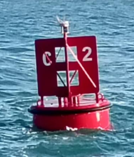
Aid to navigation Port No C2 Fl.R 10s is on its appropriate station.
53̊ 07.17 N 004̊ 24.32 W
Local Notice to Mariners 01/2026
28/02/2026 – Y Fenai – Siart 1464 – Menai Strait – Chart 1464
Bar Caernarfon Bar
Nid iw cymhorthydd mordwyo C2 ar ei safle priodol.
53̊ 07.13 Gog 004̊ 24.35 Gor
Cynghorir morwyr i fod yn ofalus yn y ardal hwn.
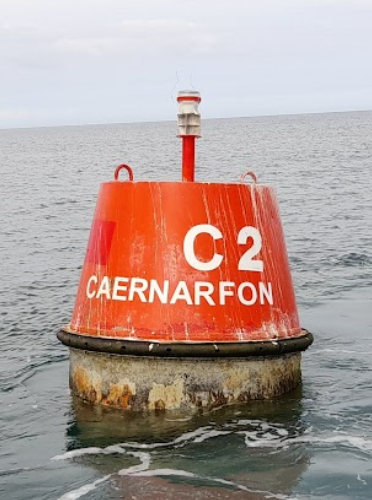
Aid to navigation C2 is not on its appropriate station.
53̊ 07.13 N 004̊ 24.35 W
Mariners are advised to exercise caution in this area.
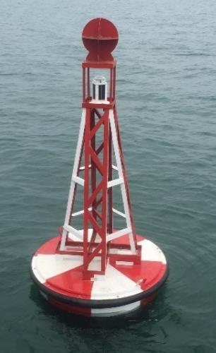
Local Notice to Mariners 34/2025
09/12/2025 – Y Fenai – Siart 1464 – Menai Strait – Chart 1464
Menai Strait
Cynghorir morwyr fod Gardinal De “Craig Swelly” Mae’r gardinal wedi’i oleuo.
53̊ 13.16 Gog 004̊ 10.45 Gor
Mae Hysbysiad i Forwyr 33/2025 yn cael ei ganslo drwy hyn.
Mariners are advised that the Swelly Rock South Cardinal is now lit.
53̊ 13.16 N 004̊ 10.45 W
Notice to Mariners 33/2025 is hereby cancelled.
Local Notice to Mariners 33/2025
09/12/2025 – Y Fenai – Siart 1464 – Menai Strait – Chart 1464
Menai Strait
Cynghorir morwyr mae’r Gardinal De “Craig Swelly” heb golau.
53̊ 13.16 Gog 004̊ 10.45 Gor
Cynghorir morwyr i fordwyo gyda gofal yn yr ardal hon.
Mariners are advised that the Swelly Rock South Cardinal is unlit.
53̊ 13.16 N 004̊ 10.45 W
Mariners are advised to navigate with caution in this area.
Local Notice to Mariners 32/2025
10/10/2025 – Y Fenai – Siart 1464 – Menai Strait – Chart 1464
Bar Caernarfon Bar
Nid yw cymhorthydd mordwyo Bwi Tramwyo L.Fl.10s ar ei safle priodol.
53̊ 06.95 Gog 004̊ 25.14 Gor
Mae’r cymhorthydd mordwyo wedi derfynwyd dros dro ar gyfer y gaeaf.
Aid to navigation Fairway Buoy L FL10s is not on station.
53̊ 06.95 N 004̊ 25.14 W
The Aid to navigation has been temporarily discontinued for the winter.
Local Notice to Mariners 31/2025
10/10/2025 – Y Fenai – Siart 1464 – Menai Strait – Chart 1464
Bar Caernarfon Bar
Mae cymhorthydd mordwyo Port Rhif C8 Fl.R.3s ar ei safle.
53̊ 07.63 Gog 004̊ 19.43 Gor
Mae Hysbysiad i Forwyr 28/2025 yn cael ei ganslo drwy hyn.
Aid to navigation Port No C8 Fl.R.3s is on station.
53̊ 07.63 N 004̊ 19.43 W
Notice to Mariners 28/2025 is hereby cancelled.
Local Notice to Mariners 30/2025
10/10/2025 – Y Fenai – Siart 1464 – Menai Strait – Chart 1464
Bar Caernarfon Bar
Mae cymhorthydd mordwyo Starbord “Traeth Gwyllt” Fl(2)G.10s ar ei safle.
53̊ 09.53 Gog 004̊ 15.89 Gor
Mae Hysbysiad i Forwyr 29/2025 yn cael ei ganslo drwy hyn.
Aid to navigation Starboard “Traeth Gwyllt” Fl(2)G.10s is on station.
53̊ 09.53 N 004̊ 15.89 W
Notice to Mariners 29/2025 is hereby cancelled.
Local Notice to Mariners 29/2025
09/10/2025 – Y Fenai – Siart 1464 – Menai Strait – Chart 1464
Bar Caernarfon Bar
Nid yw cymhorthydd mordwyo Starbord “Traeth Gwyllt” Fl(2)G.10s ar ei safle.
53̊ 09.53 Gog 004̊ 15.89 Gor
Cynghorir morwyr i fordwyo gyda gofal yn yr ardal hon.
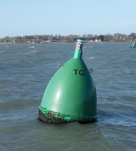
Aid to navigation Starboard “Traeth Gwyllt” Fl(2)G.10s is off station.
53̊ 09.53 N 004̊ 15.89 W
Mariners are advised to navigate with caution in this area.
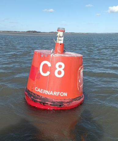
Local Notice to Mariners 28/2025
09/10/2025 – Y Fenai – Siart 1464 – Menai Strait – Chart 1464
Bar Caernarfon Bar
NID yw cymhorthydd mordwyo Port Rhif C8 Fl.R.3s ar safle.
53̊ 07.63 Gog 004̊ 19.43 Gor
Cynghorir morwyr i fordwyo gyda gofal yn yr ardal hon.
Aid to navigation Port No C8 Fl.R.3s is NOT on station.
53̊ 07.63 N 004̊ 19.43 W
Mariners are advised to navigate with caution in this area.
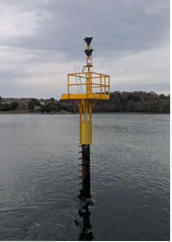
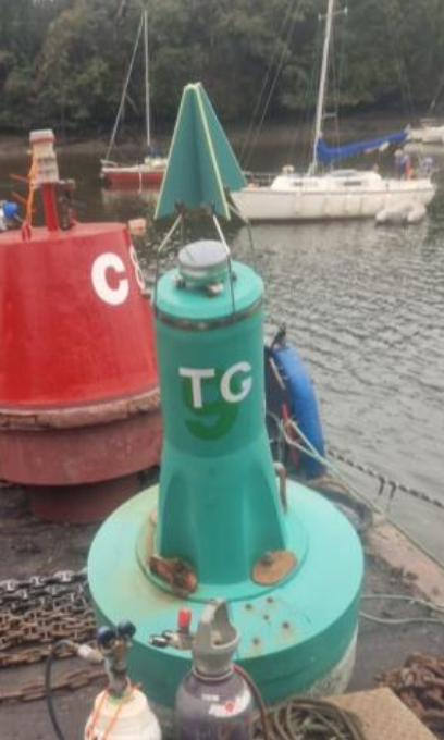
Local Notice to Mariners 26/2025
24/09/2025 – Y Fenai – Siart 1464 – Menai Strait – Chart 1464
Menai Strait
Mae cymhorthydd mordwyo Starboard rhif C9 ( Y Felinheli) Fl(3).G 10s nawr ar ei safle newydd.
53̊ 10.62 Gog 004̊ 13.82 Gor
Cynghori Morwyr mae’r rhybudd hon yn cymryd lle rhybudd 02/2021.
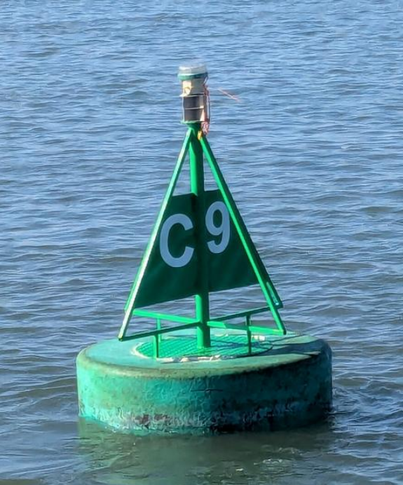
Aid to Navigation Starboard No C9 ( Y Felinheli) Fl(3).G 10s is now on its new station
53̊ 10.62 N 004̊ 13.82 W
Mariners are advised that this warning replaces warning 02/2021.
Local Notice to Mariners 25/2025
15/08/2025 – Y Fenai – Siart 1464 – Menai Strait – Chart 1464
Menai Strait
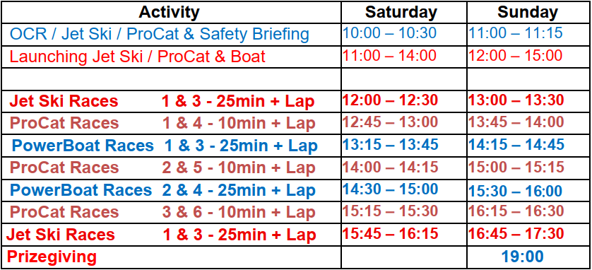
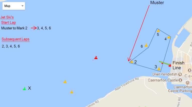
Ymhellach i NtoM 23/2025 gweler yr amseroedd rasio wedi’u cadarnhau ar gyfer digwyddiad rasio cychod pŵer OCRDA blynyddol.
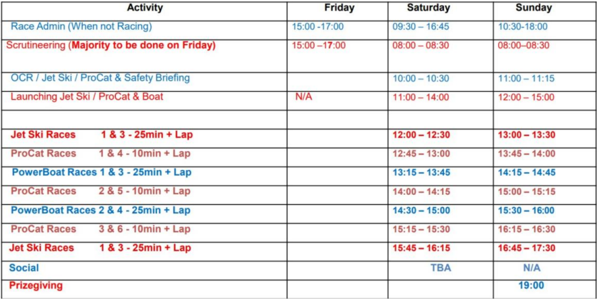
Further to NtoM 23/2025 please see the confirmed race times for the annual OCRDA Powerboat racing event.
Local Notice to Mariners 23/2025
07/08/2025 – Y Fenai – Siart 1464 – Menai Strait – Chart 1464
Menai Strait
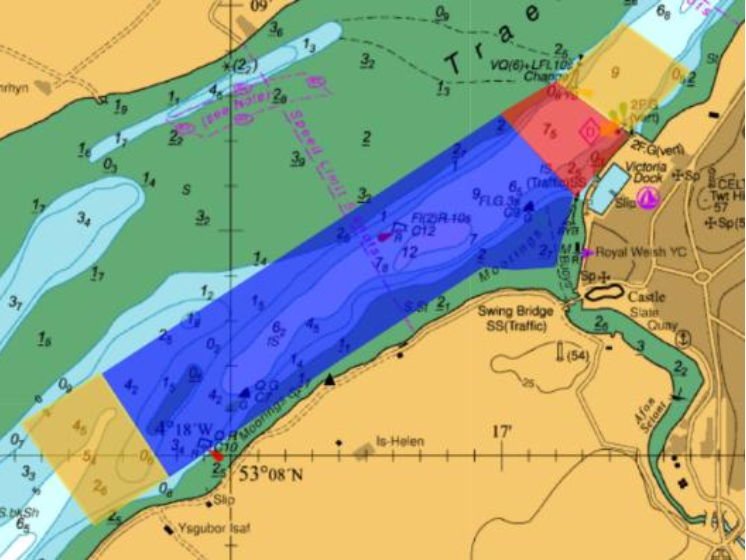
Ar ddydd Sadwrn 15 a dydd Sul 16 o Awst mae Harbwr Caernarfon yn cynnal y OCRDA Rasio Cychod Pŵer blynyddol.
Cynghorir Morwyr y bydd rasio cychod pŵer yn yr ardal tu allan i’r Afon Seiont a Doc Fictoria. Bydd oedi posibl mewn gall llywio i mewn ac allan o’r Afon Seiont a Doc Fictoria. Byddwch yn amyneddgar a dilynwch geisiadau’r swyddogion os gwellwch yn dda.
Mae mordwyo y tu mewn i’r ardal GLAS yn gwahardd yn llym yn ystod yr amseroedd rasio.
Cysylltwch â Meistr Doc am ragor o wybodaeth ar y diwrnodau rasio. VHF ch 80
Gall amseroedd newid ar fyr rybudd.
On Saturday the 15th and Sunday the 16th of Augst Caernarfon Harbour is hosting the annual OCRDA Powerboat racing.
Mariners are advised that there will be Powerboat and Jest ski racing in the area outside the River Seiont and Victoria Dock There will be potential delays in being able to navigate inbound and outbound of both the River Seiont and the Victoria Dock. Please be patient and follow the official’s requests.
Navigation inside the BLUE area is strictly prohibited during the racing times.
Please contact the Dock Master on VHF ch80 for further info on the race days.
Timings are subject to change at short notice.
Local Notice to Mariners 22/2025
17/07/2025 – Y Fenai – Siart 1464 – Menai Strait – Chart 1464
Bar Caernarfon Bar
Mae yr cymhorthydd mordwyo Aber Menai Point ar ei safle priodol ac yn dangos goleuadau priodol.
Y safle siartredig yw 53̊ 7.619 Gog 004̊ 19.715 Gor
Aid to Navigation Aber Menai Point is on station and showing it’s appropriate lights.
The land mark’s position is 53̊ 7.619 N 004̊ 19.715 W
Local Notice to Mariners 21/2025
16/07/2025 – Y Fenai – Siart 1464 – Menai Strait – Chart 1464
Bar Caernarfon Bar
Mae yr cymhorthydd mordwyo Aber Menai Point ar ei safle priodol ond nid yw yn dangos goleuadau priodol.
Y safle siartredig yw 53̊ 7.619 Gog 004̊ 19.715 Gor
Cynghorir morwyr i fordwyo gyda gofal yn yr ardal hon.
Aid to Navigation Aber Menai Point is on station but not showing its appropriate lights.
The land mark’s position is 53̊ 7.619 N 004̊ 19.715 W
Mariners are advised to navigate with caution in this area.
Local Notice to Mariners 20/2025
15/07/2025 – Y Fenai – Siart 1464 – Menai Strait – Chart 1464
Bar Caernarfon Bar
Nid yw cymhorthydd mordwyo Aber Menai Point ar ei safle priodol.
Y safle siartredig llongddrylliadau yw 53̊ 7.619 Gog 004̊ 19.715 Gor.
Cynghorir morwyr i fordwyo gyda gofal yn yr ardal hon.
 Aid to Navigation Aber Menai Point is not on station.
The buoy’s charted position is 53̊ 7.619 N 004̊ 19.715 W
Mariners are advised to navigate with caution in this area.
Local Notice to Mariners 19/2025
04/07/2025 – Y Fenai – Siart 1464 – Menai Strait – Chart 1464
Cynghorir morwyr am safleoedd cyfredol y Cymhorthion Mordwyo a restrir isod.
Mariners are advised of the current positions of the Aids to Navigation listed below.
| Aid to Navigation | Approximate Depth (5 metres off correct side of AtoN, adjusted to CD). WARNING: Depth will be affected by wind, atmospheric pressure and sea state. | Latitude | Longitude | Light |
|---|---|---|---|---|
| Change of detail since last report. | ||||
| LLANDDWYN ISLAND SW ROCK BUOY S CARDINAL | 10.1m | 53ᵒ 07’.81 N | 004ᵒ25’.05 W | Unlit |
| LLANDDWYN ISLAND NE ROCK BUOY S CARDINAL | 2.67m | 53ᵒ 08’.04 N | 004ᵒ24’.47 W | Unlit |
| SAFE WATER MARK | OFF STATION FOR WINTER | 53ᵒ 06’.96N | 004ᵒ25'.11 W | L Fl.10s |
| C 1 STARBOARD | 6.03m | 53ᵒ 07’.00 N | 004ᵒ24’.69 W | Fl.G.5s |
| C 2 PORT | 1.47m | 53ᵒ 07’.13N | 004ᵒ24’.35 W | Fl.R.10s |
| C 3 STARBOARD | 2.91m | 53ᵒ 07’.23 N | 004ᵒ 23’.88 W | Q.G |
| C 4 PORT | 2.93m | 53ᵒ 07’.12 N | 004ᵒ22’.74 W | Q.R |
| GRAMPIAN CASTLE S CARDINAL | 1.78m | 53ᵒ 07’.26 N | 004ᵒ 22’.96 W | VQ(6)+LFl.10s |
| C 5 STARBOARD | 1.53m | 53ᵒ 07’.19 N | 004ᵒ23’.37 W | Fl.G(2).5s |
| C 6 PORT | 3.04m | 53ᵒ 07’.16 N | 004ᵒ21’.97 W | Fl.R.5s |
| MUSSEL BANK PERCH | 3.84m | 53ᵒ 07’.32 N | 004ᵒ20’.92 W | Fl.R(2).5s |
| C 8 PORT | 5.54m | 53ᵒ 07’.63N | 004ᵒ19’.43 W | Fl.R.3s |
| C 10 PORT | 2.89m | 53ᵒ 07’.95 N | 004ᵒ18’.25 W | Q.R |
| C 7 STARBOARD | 3.32m | 53ᵒ 08’.13 N | 004ᵒ18’.02 W | Q.G |
| C 12 PORT | 1.6m | 53ᵒ 08’.48 N | 004ᵒ17’.39 W | Fl(2)R.10s |
| C 9 STARBOARD | 3.7m | 53ᵒ 08’.54 N | 004ᵒ16’.91 W | Fl.G.2s |
| CHANGE BUOY S CARDINAL | 4.24m | 53ᵒ 08’.80 N | 004ᵒ16’.74 W | VQ(6)+LFl.10s |
| SEIONT RIVER BIFURCATION | 0.13m | 53ᵒ 08’.55 N | 004ᵒ16’.81 W | Unlit |
| TRAETH GWYLLT STARBOARD | 2.78m | 53ᵒ 09’.27 N | 004ᵒ16’.09 W | Fl(2)G.10s |
| C 13 STARBOARD | 2.71m | 53ᵒ 09’.53 N | 004ᵒ15’.89 W | Fl(4)G.10s |
| C 11 STARBOARD | 3.85m | 53ᵒ 09’.88 N | 004ᵒ15’.63 W | Fl(2)G.5s |
| C 14 PORT | 5.28m | 53ᵒ 10’.19 N | 004ᵒ15’.50 W | Fl.R.5s |
| C TEMP PORT | 4.92m | 53ᵒ 10’.53 N | 004ᵒ14’.67 W | FL(2)R.5s |
| C 9 STARBOARD PORT DINORWIC | 2.96m | 53ᵒ 10.63N | 004ᵒ13’.82W | FL(3)G.10s |
Local Notice to Mariners 18/2025
01/04/2025 – Y Fenai – Siart 1464 – Menai Strait – Chart 1464
Y Felinheli – Port Dionorwic
Mae tri Marc Rasio Tymhorol wedi’u sefydlu yn y safleoedd canlynol:
CHYF 3 – 53˚10.867N 004˚ 13. 476W
CHYF 4 – 53˚11.110N 004˚ 13. 095W
CHYF 5 – 53˚11.326N 004˚ 12. 936W
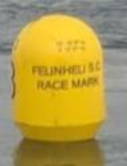
Three Seasonal Race Marks have been established in the following positions:
PDSC 3 – 53˚ 10.87N 004˚ 13. 47W
PDSC 4 – 53˚ 11.11N 004˚ 13. 09W
PDSC 5 – 53˚ 11.32N 004˚ 12. 93W
Longterm Notices to Mariners
Local Notice to Mariners 11/2025
01/04/2025 – Y Fenai – Siart 1464 – Menai Strait – Chart 1464
Bar Caernarfon Bar
Longddrylliad “Grampian Castle” Wreck
Mae Cardinal De sefydlog newydd VQ(6) + LFl 10s (Castell Grampian) wedi osod ar longddrylliad “Grampian Castle”.
53ᵒ07.30′ Gog 004ᵒ22.99′ Gor
A new Fixed South Cardinal VQ(6) + LFl 10s (Grampian Castle) has been affixed to the wreck of the “Grampian Castle”.
53ᵒ07.30′ N 004ᵒ22.99′ W
Local Notice to Mariners 24/2024
30/08/2024 – Y Fenai – Siart 1464 – Menai Strait – Chart 1464
Bar Caernarfon Bar
“BANC CREGYN GLEISION”
Mae nawr Cymorth Mordwyo Port newydd ar Mussel Bank, ac mae bellach yn dangos siâp dydd priodol a golau Fl R(2)5s yn y sefyllfa ganlynol.
53ᵒ07.320′ Gog 004ᵒ20.926′ Gor
“MUSSEL BANK”
A new fixed Port Aid to Navigation on Mussel Bank, has been completed and is now demonstrating an appropriate day shape and light Fl R(2)5s is the following position.
53ᵒ07.320′ N 004ᵒ20.926′ W
Local Notice to Mariners 19/2021
02/07/2021 – Y Fenai – Siart 1464 – Menai Strait – Chart 1464
Cynghorir morwyr bod yr ardal a amlygir isod ar y siart, yn benodol o amgylch C7 ac C12 wedi datblygu banc tywod sydd rhyw 1 metr yn uwch na Chart Datwm.
Cynghorir morwyr i gymryd rhybudd a rhoi sylw dyledus i’r dyfnder dŵr sydd ar gael wrth fordwyo yn yr ardal hon.
Mariners are advised that the area highlighted below on the chart, specifically around C7 and C12 has developed a sand bank that is approximately 1 meters above Chart Datum.
Mariners are advised to take caution and have due regard for the available depth of water when navigating in this area.
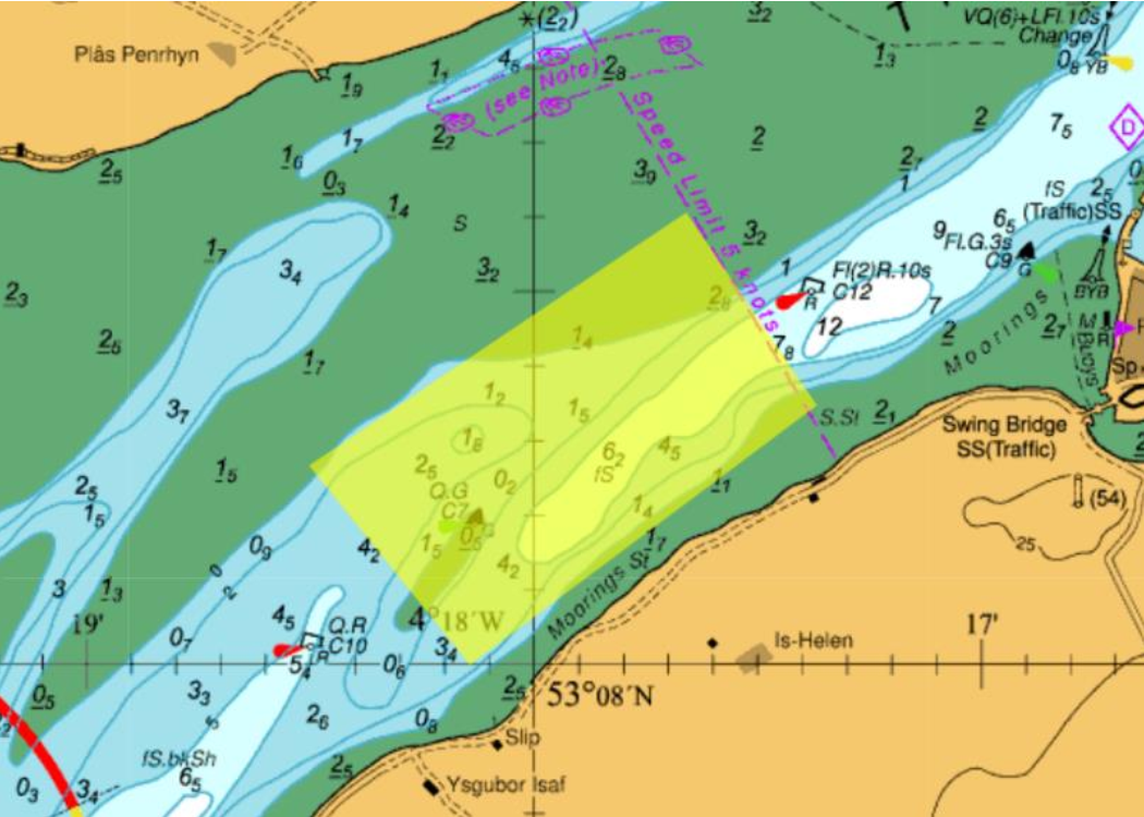
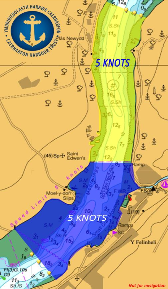
Local Notice to Mariners 12/2021
01/04/2021 – Y Fenai – Siart 1464 – Menai Strait – Chart 1464
Harbour Master’s General Direction
5 Knot Speed Limit
By virtue of the provisions of Sec. 52 Harbour, Docks and Piers Clauses Act 1847, Port and harbour of Caernarfon Harbour Master has made the following General Direction:
1. This Direction is given to Masters (see note a) and persons having command or charge of any vessel (see note b) other than those vessels listed in paragraph 4(i) to 4(v).
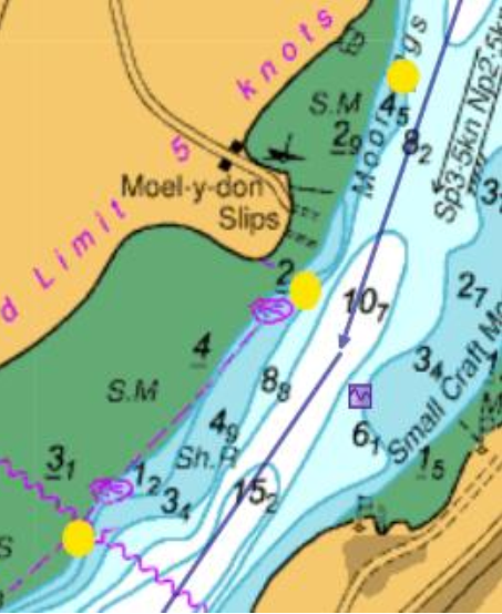
2. This Direction applies at all times and in the area north of the existing and active speed limit at Y Felinheli. (Now known as the “Y Felinheli to Garreg Ginnog” Area of General Direction). The “Y Felinheli to Garreg Ginnog” means the area below the level of mean high water spring tides bounded by a line drawn along the northern extent of the existing charted speed limit at Y Felinheli and through to a new line drawn from a point 53ᵒ12.30’N 004ᵒ12.44’W to a point 53ᵒ12.40’ N 044ᵒ12.82’W. (Illustrative chart extract at end of NtoM).
3. At the Northern and Southern extent of the entire speed limit. Special Marks will be positioned to demark the area.
4. This Direction is not given to Masters and persons having command or charge of vessels:
(i) used by search and rescue organisations
(ii) of the Caernarfon Harbour Authority
(iii) of HM Customs and Excise
(iv) vessels under sail.
(v) used as safety boats by Yacht and Sailing Clubs and other such organisations when engaged in operations where complying with this Direction would inhibit their ability to fulfil their function as a safety boat
5. No vessel, except those listed in paragraphs 4(i) to 4(v), shall proceed at a speed of greater than 5 knots.
6. This Direction is given notwithstanding the requirements of the International Regulations for Preventing Collisions at Sea (see note c) and The Port and Harbour of Caernarfon Bylaws 1991 (see note d).
7. Not to comply with this Direction is a criminal offence for which the person having command or charge of the vessel may be prosecuted (see note e).
8. The Harbour Master or his deputies will be actively monitoring the compliance with this General Direction.
David John O’Neill
Caernarfon Harbour Master
Notes
a Sec.3 Harbour, Docks and Pier Clauses Act 1847
b As defined in the Port and Harbour of Caernarfon Bylaws 1991.
c Merchant Shipping (Distress Signals and Prevention of Collisions) Regulations 1996 [SI 75/1996]
d Port and Harbour of Caernarfon Bylaws 1991.
e Sec.3 and Sec.53 Harbour, Docks and Piers Clauses Act 1847
Owners, Agents Charterers, Marinas, Yacht Clubs and Recreational Sailing Organisations should ensure that the contents of this Notice are made known to the master or persons in charge of their vessel or craft.
Blue area denotes existing speed limit. Yellow area denotes new area of General Direction.
Local Notice to Mariners 14/2019
16/05/2019 – Y Fenai – Siart 1464 – Menai Strait – Chart 1464
Menai Strait
Cynghorir morwyr bod yr ardal a amlygir isod ar y siart, yn benodol o C11 er i C9 wedi datblygu banc tywod sydd rhyw 0.5 metr o ddŵr yn is na Chart Datwm.
Cynghorir morwyr i gymryd rhybudd a rhoi sylw dyledus i’r dyfnder dŵr sydd ar gael wrth fordwyo yn yr ardal hon.
Mariners are advised that the area highlighted below on the chart, specifically from C11 though to C9 has developed a sand bank that has approximately 0.5 meters of water below Chart Datum.
Mariners are advised to take caution and have due regard for the available depth of water when navigating in this area.